

Toby J. Grzejka PG
The NMMR 50th Anniversary Celebration continues with the presentation of “A New Look at an Old Problem: The 3D rendering of Subsurface Mining Conditions and Mine Fire Progression for Areas Surrounding Centralia; Columbia and Schuylkill Counties, Pennsylvania.”
Centralia, like many other small towns within the anthracite region of Pennsylvania was home to many miners and their families who worked at the nearby collieries.
Little did they know that in the early 1960’s they would make national news and ultimately abandon their town when a coal seam caught fire.
Several years of fighting the fire proved that it was more resilient than expected.
To protect the health of the town’s citizens, their homes were purchased by the government, and the buildings razed.
By the 1980’s, Centralia effectively became a ghost town.
Today, over 50 years later, the fire continues to burn, and the monitoring of the fires’ progression continues.
During the NMMR’s 50th Anniversary year, the idea of creating a 3D Model of the underground mine workings and the fire progression was proposed. The goal of the model is to promote the importance of collecting and archiving mine maps because of the information they contain and how it can be used with modern computer technology.
With the combined efforts of OSMRE’s GIS and NMMR teams, the model slowly started to take on an appearance that before had only been imagined. 15 coal seams were digitized and modeled, instantly showing the complexity of the local geology. This model quickly grew to become one of OSMRE’s most complex models ever attempted. Other mine features were also digitized, such as the coal mining travel ways, mine pools, shaft and slope locations, outflows, and of course, the progression of the fire.
Future modeling will involve the addition of the PADEP’s monitoring files and the use of drones to obtain current thermal imaging.
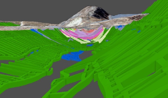
Upon analysis of the model, created from the area’ existing mine maps, several new mine features were able to be developed: the limits of burnable coal, limits and direction of the coal burn, and potential future burn areas. Picture 1 shows the 3D mine workings in and around Centralia, Pennsylvania. Each color is a different seam and consist of (starting at the bottom); Blue – Buck Mountain, Purple – Skidmore, Green – Mammoth, Yellow – Mammoth Leader, Orange – Four Foot, Pink – Bottom Split of the Holmes, Light Purple – Top Split of the Holmes, Pale Brown – Primrose Underlayment, and finally Dark Orange – Primrose Seam.
When one builds a 3D model such as this, you cannot help yourself by looking at it and asking yourself, “is there a way to put it out?” Well as it turns out, possibly mitigations were conceptualized and consist of… Guess you will have to attend the re-broadcast presentation. Please stay tune for dates!