

NEPA Projects and Documentation
Below is a list of recent active surface coal mining activities requiring environmental assessments (EA) or environmental impact statements (EIS). NEPA documentation is required for the Department of the Interior to make a mining plan decision on Federal lands. Pursuant to the Fiscal Responsibility Act of 2023, EAs must be finalized in 1 year and EISs must be finalized in 2 years.
For abandoned mine land related documents, please visit the Oversight Document Database.
NEPA Documents Pending
The Falkirk Mine is located in McLean County, North Dakota. The Falkirk Mine uses standard surface strip-mining procedures to mine private and Federal coal resources. Coal is currently mined from multiple permit areas.
Background
On October 30, 2019, the Falkirk Mining Company (Falkirk) submitted a Federal coal Lease-by- Application (LBA) for its Falkirk Mine to the Bureau of Land Management (BLM) Montana/Dakotas State Office and amended their application on June 8, 2020.
BLM and OSMRE have jointly prepare an Environmental Assessment (EA) to evaluate the potential environmental effects of leasing and subsequent mining of the Federal coal tracts in accordance with NEPA, the National Historic Preservation Act, Endangered Species Act, and other applicable regulations. As joint leads in the development of the NEPA document, BLM and OSMRE will use the document to facilitate their respective decisions. OSMRE will use the document to support a Federal Mining Plan recommendation.
The LBA addresses planned activities to lease and surface mine Federal coal at the Falkirk Mine located in McLean County, North Dakota. This application has been serialized - NDM 111489. The LBA Tracts include approximately 766 acres that contain approximately 9.6 million tons of recoverable coal.
The EA was completed in August 2025, and BLM completed the coal lease sale in September 2025. OSMRE is awaiting approval from the North Dakota Public Service Commission (NDPSC) of the mining plan prior to processing a recommendation on the federal mining plan.
Relevant Documentse-Planninge-Planning
To view relevant documents, visit BLM e-Planning website – e-Planninge-Planning
- Search for NEPA number "DOI-BLM-MT-0000-2025-0005-EA"
- Select Project Name "Falkirk Mining Company Proposed Federal Coal Lease By Application NDM 111489"
- Click “Documents” on the left hand side of the screen to display documents.
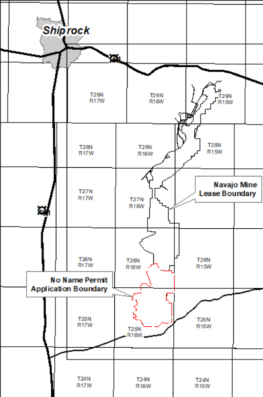
The Office of Surface Mining Reclamation and Enforcement (OSM) announced its intent to prepare an environmental impact statement for a permit for the No Name area within the existing Navajo Mine Lease 14-20-603-2505.
OSM invited the public to comment and held a public scoping meeting on Jan. 29, 2026, from 3 p.m. to 7 p.m. MT, at the Burnham Chapter House on the Navajo Nation. The scoping comment period closed on Feb. 4, 2026.
No Name
Navajo Transitional Energy Company (NTEC) operates Navajo Mine, located in Navajo Nation, approximately 22 miles from Farmington, New Mexico. The Navajo Nation owns NTEC, the surface and mineral rights of the entire lease area, and the permit areas located within it. If approved, the permit boundary would encompass 11,526 acres and authorize surface mining and reclamation operations on 9,042 acres and the recovery of approximately 503 million tons of Navajo Nation coal. NTEC supplies coal to the Four Corners Power Plant, operated by Arizona Public Service.
Navajo Transitional Energy Company’s No Name Permit Surface Mining Control & Reclamation Act Permit Application Environmental Impact Statement Schedule Unique ID: EISX EISX-010-08-000-1765812420 | ||
MILESTONE | DATE | STATUS |
Notice of Intent | January 15, 2026 | Complete |
Scoping Period | January 15, 2026 – February 4, 2026 | Complete |
EIS Publication | August 2026 | Pending |
Record of Decision | August 2026 | Pending |
All media inquiries should be directed to:
Office of Communications
U.S. Department of the Interior
Office of Surface Mining Reclamation and Enforcement
[email protected]
NEPA Documents Complete
The Department of the Interior announced its the Final Environmental Impact Statement (FEIS) for the Black Butte Mine mining plan modification. The EIS and Record of Decision were prepared in compliance with the Department’s alternative arrangements for compliance with the NEPA. On January 20, 2025, President Donald J. Trump issued Executive Order 14156 – “Declaring a National Energy Emergency,” which declared a national energy emergency and directed Federal agencies to expedite permits and approvals for energy projects, including those on Federal lands, using emergency provisions. During an emergency, a responsible official of the Department can adopt alternative arrangements to comply with NEPA before taking “urgently needed actions.”
Black Butte
The U.S. Department of the Interior, Office of Surface Mining Reclamation and Enforcement, Regions 5, 7-11 is preparing an EIS for the Black Butte Pit 10/15 mining plan modification for federal coal lease WYW-6266. In accordance with the Mineral Leasing Act of 1920, the DOI Assistant Secretary for Land and Minerals Management must approve the project before any mining and reclamation can occur on lands containing leased federal coal. Black Butte Coal operates the Black Butte Coal Mine under a permit issued by the Wyoming Department of Environmental Quality-Land Quality Division in accordance with the approved Wyoming State Coal Regulatory Program (30 CFR Part 950).
The Black Butte Mine is a surface coal mine located in Sweetwater County in southwest Wyoming approximately 25 miles east of Rock Springs. The mine produces coal from federal, private, and state lands and provides thermal coal to the Jim Bridger Power Plant. The mine has been in production since 1977 and is expected to continue to operate until 2039 in accordance with Jim Bridger Power Plant’s Integrated Resource Plan. The proposed mining plan modification would allow approximately 257 acres of additional surface disturbance and 9.2 million tons of federal coal to be mined. Expected average production rate is between 500,000 to 1.3 million tons per year (Mtpy), which is below the maximum permitted production rate of 5 Mtpy established by WDEQ Air Quality Permit #P0026670. Using the estimated 1.3 Mtpy production rate, the Project would extend the life of the mine by approximately 5 to 10 years, depending on demand.
Black Butte Federal Coal Lease WYW-6266 Mining Plan Modification EIS schedule | ||
|---|---|---|
MILESTONE | DATE | STATUS |
Notice of Intent | August 12, 2025 | Complete |
| Scoping Period | August 12 - 22, 2025 | Complete |
EIS Publication | September 9, 2025 | Complete |
Record of Decision | September 9, 2025 | Complete |
For more information contact the OSMRE Project Manager:
Marcelo Calle
U.S. Department of the Interior
Office of Surface Mining Reclamation and Enforcement
[email protected]
Telephone: (303) 236-2929
All media inquiries should be directed to:
Office of Communications
U.S. Department of the Interior
Office of Surface Mining Reclamation and Enforcement
[email protected]
The Department of the Interior announces the availability of the Final EIS and Record of Decision for the Bull Mountains Mine No. 1 Amendment 3 mining plan modification. The Final EIS and Record of Decision were prepared in compliance with the Department’s alternative arrangements for compliance with the NEPA. On January 20, 2025, President Donald J. Trump issued Executive Order 14156 – “Declaring a National Energy Emergency,” which declared a national energy emergency and directed Federal agencies to expedite permits and approvals for energy projects, including those on Federal lands, using emergency provisions. During an emergency, a responsible official of the Department can adopt alternative arrangements to comply with NEPA before taking “urgently needed actions.”
Bull Mountains Mine No. 1 EIS
Bull Mountains Mine No. 1, operated by Signal Peak Energy, LLC, is located 30 miles north of Billings, Montana, on private and public land in Musselshell and Yellowstone Counties. The proposed project would allow 247 acres of surface disturbance and recovery of 24 million tons of Federal coal. The EIS analyzes the Bull Mountains Mine No. 1 mining plan modification associated with Federal Coal Lease MTM 97988. OSMRE prepared this EIS for the Bull Mountains Mine No. 1 Amendment 3, as directed by the October 14, 2022, U.S. District Court of Montana court ruling, to address the deficiencies identified in OSMRE’s 2018 EA.
Bull Mountains Mine No. 1 Mine EIS Schedule | ||
|---|---|---|
| MILESTONE | DATE | STATUS |
| Notice of Intent | August 7, 2023 | Complete |
| Draft EIS Publication | N/A | Energy Emergency Alternative Arrangements |
| Draft EIS 45-Day Comment Period | N/A | Energy Emergency Alternative Arrangements |
| Final EIS | June 6, 2025 | Complete |
| Record of Decision | June 6, 2025 | Complete |
For more information contact the OSMRE Project Manager:
Marcelo Calle
U.S. Department of the Interior
Office of Surface Mining Reclamation and Enforcement
[email protected]
Telephone: (303) 236-2929
All media inquiries should be directed to:
Office of Communications
U.S. Department of the Interior
Office of Surface Mining Reclamation and Enforcement
[email protected]
The Freedom Mine is located in Mercer County, North Dakota. The Freedom Mine uses standard surface strip-mining procedures to mine private and Federal coal resources. Coal is currently mined from multiple permit areas.
Background
On May 17, 2019, Coteau Properties Company (Coteau) submitted an emergency Federal coal LBA (serial number NDM 111186) for its Freedom Mine to the BLM Montana/Dakotas State Office to lease multiple Federal tracts containing approximately 14.5 million tons of minable coal over 880 acres through 2045 (Coteau 2019). On December 17, 2021, Coteau submitted a revised emergency Federal coal LBA for serial number NDM-111186 to lease about 24.1 million tons of minable coal over 1,350 acres through 2045 (Coteau 2021). All Federal lease tracts are in Mercer County, North Dakota.
An EA has been prepared jointly by the Bureau of Land Management (BLM) and Office of Surface Mining and Enforcement (OSMRE) to disclose and analyze the potential effects on the environment of issuing a Federal coal lease for the proposed Lease-by-Application (LBA) NDM-111186 and recommendation of approval of the associated Federal mining plan modification by OSMRE to the Assistant Secretary of Lands and Minerals (ASLM) enabling the Federal coal to be mined.
The EA has been prepared to also disclose and analyze the potential effects on the environment of adding Federal coal reserves from Federal Coal Lease NDM-091535 to its existing State Permit NACT-0201 via Revision 28 and Renewal 4 at Freedom Mine. Based on OSMRE’s review of the Revision 28 and Renewal 4, OSMRE has determined that the action constitutes a federal mine plan modification requiring approval by the ASLM. The federal mining plan modification covers 640 acres and 8.4 million tons of federal coal that would be mined over the next 5 years.
The EA was completed in August 14, 2025, and BLM completed the coal lease sale in September 3, 2025.
Freedom Mine, Federal Coal Lease NDM-91535 Mining Plan Modification EA schedule | ||
|---|---|---|
MILESTONE | DATE | STATUS |
| Draft EA Publication | March 31, 2025 | Complete |
Public Comment Period | April 1 - May 2, 2025 | Complete |
| Final EA Publication | August 14, 2025 | Complete |
| BLM's FONSI and EA Publication | September 2, 2025 | Complete |
OSMRE's FONSI Signed | October 20, 2025 | Complete |
Federal Mining Plan Modification Approval | October 29, 2025 | Complete |
Final Environmental Assessment (EA)
Finding of No Significant Impact (FONSI)
Contact
All media inquiries should be directed to:
Office of Communications
U.S. Department of the Interior
Office of Surface Mining Reclamation and Enforcement
[email protected]
The Department of the Interior announces the availability of the Environmental Assessment and Finding of No Significant Impact for Hurricane Creek Mine #2. The EA and Finding of No Significant Impact were prepared in compliance with the Department’s alternative arrangements for compliance with NEPA. On January 20, 2025, President Donald J. Trump issued Executive Order 14156- “Declaring a National Energy Emergency”, which declared a national energy emergency and directed Federal agencies to expedite permits and approvals for energy projects using emergency procedures. During an emergency, a responsible official of the Department can adopt alternative arrangements to comply with NEPA before taking “urgently needed actions”.
OSMRE is the regulatory authority that issues and administers permits in Tennessee. The EA was prepared to evaluate the environmental impacts, pursuant to the requirements of NEPA. Hurricane Creek Mine #2, proposed by Hurricane Creek Mining, LLC, is located in Claiborne County, Tennessee. The proposed project consists of approximately 635 acres of surface disturbance in a mine area affected by both SMCRA and pre-law coal mining activities that would recover 1.8 million tons of specialty market and thermal use coal over a span of up to 10 years.
For more information contact:
Don Hall
U.S. Department of the Interior
Office of Surface Mining Reclamation and Enforcement
Telephone: (859) 205-6723
All media inquiries should be directed to:
Office of Communications
U.S. Department of the Interior
Office of Surface Mining Reclamation and Enforcement
The Mountain State Broadband Expressway (MSBE) project is an initiative of the Upshur County Regional Development Authority (UCDA) to address limiting factors for broadband proliferation in 20 counties in West Virginia and therein create needed infrastructure for economic development. The MSBE Project’s mission is to construct fiber-connected towers on or adjacent to Abandoned Mine Land (AML) sites to expand fiber resources into unserved and underserved areas to facilitate competitive providers’ offering of broadband services.
Background
A Programmatic Environmental Assessment (PEA), complying with the National Environmental Policy Act (NEPA) was published separately for the MSBE Project. The PEA also addresses the phasing of the site identification, environmental reviews for the specific construction activities, and references the development of this Programmatic Agreement (PA).
Notice of Availability of Programmatic Agreement For Section 106 of The National Historic Preservation Act of 1969
The U.S. Department of the Interior (DOI), Office of Surface Mining Reclamation and Enforcement (OSMRE) Interior Regions 1 and 2—a bureau of the U.S. Department of the Interior—has prepared a draft programmatic agreement (PA) to comply with National Historic Preservation Act of 1969 (NHPA) Section 106 consultation procedures. This document applies to an Abandoned Mine Land Reclamation Economic Development Pilot Program (AML Pilot Program) project, entitled the Mountain State Broadband Expressway (MSBE), proposed by the Upshur County Regional Development Authority (UCDA). The MSBE project is an initiative of the UCDA to address limiting factors for broadband proliferation in 20 counties in West Virginia and therein create needed infrastructure for economic development. The MSBE Project’s mission is to construct fiber-connected towers on or adjacent to AML sites to expand fiber resources into unserved and underserved areas to facilitate competitive providers’ offering of broadband services. OSMRE has prepared this PA to address the phasing of site identification and specific construction activities and to provide an overall process to evaluate and assess the historic, cultural, and tribal resources and any potential effects as the sites are located.
The PA has been prepared in accordance with 54 U.S.C. § 306108 (Section 106) of the NHPA 54 U.S.C. §§ 300101-307108, the implementing regulations at 36 C.F.R. Part 800, and the Presidential Executive Order 13175, Presidential Memorandum on Tribal Consultation. Federal agencies are required to take into account the effect of their undertakings on historic and cultural properties and provide the Advisory Council on Historic Preservation (ACHP) a reasonable opportunity to comment on those effects. Pursuant to 36 C.F.R. § 800.16(y), an “undertaking” is defined as a “project, activity or program funded in whole or part under the direct or indirect jurisdiction of a federal agency”. For undertakings, such as the MSBE, for which Section 106 is applicable, OSMRE must complete the consultation process to comply with statutory requirements.
Relevant Documents
- Programmatic Environmental Assessment (PEA) (Dated 07/02/2020)
- Finding of No Significant Impact (FONSI) (Dated 07/02/2020)
Contact
For more information contact the OSMRE Federal Preservation Officer:
Stephanie R. Hamlett
[email protected]
Telephone: (202) 208-2802
The Rosebud Mine, operated by Westmoreland Rosebud Mining, LLC is an existing coal mine in Colstrip (Treasure and Rosebud Counties), Montana, approximately 90 miles east of Billings. OSMRE prepared this Rosebud Mine Area F Final Supplemental Environmental Impact Statement (SEIS) to address the deficiencies identified by the United States District Court for the District of Montana (Montana Env’t Info. Ctr. v. Haaland, No. CV 19-130-BLG-SPW, 2022 U.S. Dist. LEXIS 179417) in the 2018 Western Energy Area F Final Environmental Impact Statement. This SEIS supplements the 2018 Final EIS, which was prepared by OSMRE and the Montana Department of Environmental Quality. The proposed Project would allow 4,288 acres of surface disturbance and recovery of a 71.3 million tons (33.75 million tons Federal coal, 37.56 million tons private) of coal. The SEIS analyzes Mining Plan Modification to include Federal Coal Lease MTM 082186 in their existing Montana State Permit No. C2011003F.
Rosebud Mine Area F Supplemental EIS Schedule | ||
|---|---|---|
| MILESTONE | DATE | STATUS |
| Notice of Intent | N/A | N/A |
| Draft EIS Publication | December 6, 2024 | Complete |
| Draft EIS 45-Day Comment Period | December 6, 2024 - January 21, 2025 | Closed |
| Final EIS and Record of Decision | August 4, 2025 | Complete |
Rosebud Mine Area F Supplemental Environmental Impact Statement
Rosebud Mine Area F Record of Decision
Rosebud Mine Area F Federal Mining Plan Modification Approval Document
Contact
All media inquiries should be directed to:
Office of Communications
U.S. Department of the Interior
Office of Surface Mining Reclamation and Enforcement
[email protected]
The Spring Creek Mine, operated by Navajo Transitional Energy Company, is approximately 32 miles from Sheridan, Wyoming on private and public lands in Big Horn County, Montana. The proposed project would allow 162.5 acres of surface disturbance and recovery of 39.9 million tons of Federal coal. The EIS analyzes the Spring Creek Mining Plan Modification for Federal Coal Leases MTM 94378 and MTM 110693. OSMRE prepared this EIS, as directed by the August 5, 2021, District Court of Montana court ruling to address deficiencies in OSMRE's 2016 EA.
Spring Creek Mine EIS Schedule | ||
|---|---|---|
| MILESTONE | DATE | STATUS |
| Notice of Intent | March 17, 2022 | Complete |
| Draft EIS Publication | September 4, 2024 | Complete |
| Draft EIS 45-Day Comment Period | September 6, 2024 - October 21, 2024 | Closed |
| Final EIS | January 10, 2025 | Complete |
| Record of Decision | March 7, 2025 | Complete |
For more information contact the OSMRE Project Manager:
Marcelo Calle
U.S. Department of the Interior
Office of Surface Mining Reclamation and Enforcement
[email protected]
Telephone: (303) 236-2929
All media inquiries should be directed to:
Office of Communications
U.S. Department of the Interior
Office of Surface Mining Reclamation and Enforcement
[email protected]
Mine No. 4 and Blue Creek Mine No.1 are located in Tuscaloosa County, Alabama within the Warrior Basin. Mine No. 4 and Blue Creek Mine No. 1 are existing deep-shaft underground mines operated by Warrior Met under state-issued SMCRA Permit Nos. P-3260 and P-3964, producing high-quality metallurgical coal.
Background
On September 30, 2025, the Bureau of Land Management (BLM) conducted competitive lease sales for Federal coal tracts ALES-055797 and ALES-056519 and issued the leases to Warrior Met Coal, effective December 2, 2025. The BLM, in collaboration with OSM and the Alabama Surface Mining Commission, prepared an environmental impact statement to analyze the environmental impacts associated with leasing the Federal coal tracts and reasonably foreseeable mining development. The ASMC amended Warrior Met’s approved operations and reclamation plans on January 6, 2026.
The proposed action involves the extraction of 53.2 million tons of Federal metallurgical coal resources, approximately 14,050 acres of Federal coal in the leased federal tracts. Pursuant to 30 CFR Part 746, OSM is responsible for reviewing proposed mining plans for Federal coal leases ALES-055797 (Mine No. 4) and ALES-05619 (Blue Creek No. 1) and submitting a recommendation to the ASLM for approval, disapproval, or conditional approval of the mining plans.
Relevant Documents
Final Environmental Impact Statement
Record of Decision
Contact:
All media inquiries should be directed to:
Office of Communications
U.S. Department of the Interior
Office of Surface Mining Reclamation and Enforcement
[email protected]
The Antelope Mine is located in Converse County, Wyoming. Coal at the Antelope Mine is mined using conventional surface-mining methods and shipped from an onsite railroad loading facility to electric utilities and industrial customers in the U.S.
Background
The U.S. Department of the Interior, Office of Surface Mining Reclamation and Enforcement, Regions 5, 7-11 is preparing an environmental assessment (EA) for the Navajo Transitional Energy Company (NTEC) Antelope Mine West Antelope II South Modification Tract (West Antelope) Mining Plan Modification to incorporate the WYW-177903 Federal coal lease modification at the Antelope Mine in Converse County, Wyoming. In accordance with the Mineral Leasing Act of 1920, the Department of the Interior Assistant Secretary for Land and Minerals Management must approve the project before any mining and reclamation can occur on lands containing leased federal coal. NTEC operates the Antelope Mine under a permit issued by the Wyoming Department of Environmental Quality-Land Quality Division in accordance with the approved Wyoming State Coal Regulatory Program (30 CFR Part 950).
The Department of the Interior prepared the EA to evaluate the environmental impacts, pursuant to the requirements of the National Environmental Policy Act of 1969 (NEPA). Approval of the mining plan modification would authorize the mining of approximately 857 acres from Federal Coal Lease WYW-177903 and 14.5 million tons of recoverable Federal coal. The approval will extend the life of mine by approximately 0.5 years.
|
West Antelope EA Schedule |
||
|---|---|---|
| MILESTONE | DATE | STATUS |
| Project Scoping | November 4, 2019 - December 3, 2019 | Closed |
| Draft EA Publication | May 8, 2020 | Complete |
| Draft EA Comment Period | May 8, 2020 - June 8, 2020 |
Closed |
| Final EA | August 7, 2025 | Complete |
| Signed FONSI | August 7, 2025 | Complete |
Contact
All media inquiries should be directed to:
Office of Communications
U.S. Department of the Interior
Office of Surface Mining Reclamation and Enforcement
[email protected]